
Sunday, January 8, 2017

Monday, August 18, 2014
Millicent Wolverine & Tuscarora Hike

The trailhead for this hike is the large Brighton Ski Resort parking lot, there's no fighting for a space like Mill B South. You can park on the southeast side near the main lodge, the northwest side where the hike begins or anywhere in between depending on whether you want to cross the parking lot at the beginning or end of the hike. I like to park in the middle and look down from the summit of Mount Millicent and see my vehicle, it gives one a sense of accomplishment. There are not usually any restrooms available at the ski resort in the summer, you have to visit the "Nordic Center" along the loop about a 1/4 mile before the Brighton parking lot.
The hike starts at the base of the Milly Express ski lift at the northwest side of the parking lot. Right next to the lift begins the service road that winds back and forth climbing all the way up to the top of the ski lift. The road passes by the Twin Lakes Reservoir dam where you can stop for a photo or just enjoy the view. You can also choose to hike up the ski slope which varies from steep and grassy to smooth bedrock. The ski slope is more direct but much steeper. Save your legs for the next part if you are in doubt, there's no easy way up the boulders.
At the top of the lift begins the boulder scramble. The boulders vary from car sized to bread boxes. There's no trail, just head uphill and avoid where the pile of boulders is too steep. I like to put away the trekking pole and wear leather gloves for this part. The easiest path is near the crest of the ridge but some of the best views are on either side. There are several false peaks, the total vertical is about 600ft but feels like a lot more than six stories. There are several avalanche control devices on the sides of Mount Millicent. They look like giant faucets but appear to be nematic with hoses running all the way up the ridge from a shack. When you reach the summit be sure to take time to enjoy the view on all the sides especially on a clear day. It took me about 2 hours to reach the summit form the parking lot, I stopped to take photos and catch my breath many times.
The next part of the hike is descending down the back of Mount Millicent just enough to get up the ridge to Mount Wolverine. There are a few places you need to zig-zag around trees and boulders but try to head southwest and avoid descending to far by staying close to the southwest ridge. The terrain will turn from boulders to a grassy soil with occasional rocks as it bottoms out and you start heading up Mount Wolverine. There are some good views on the ridge towards Twin Lakes Reservoir but you can make your way up the steep meadow wherever it looks easiest. As you approach the top there is a fairly obvious trail that will lead you to the rocky top of Mount Wolverine. Though the Millicent side of Wolverine is not terribly impressive, when you look down to the southwest you will see much of the Alta ski resort. The southwest side of Wolverine is a very steep slope. On a clear day you can look out the mouth of Big Cottonwood Canyon and see the Bingham Copper Mine (Kennecott) across the Salt Lake valley. Many of the famous peaks of the area are visible including American Fork Twin Peaks, Lone Peak, Mount Baldy and the red peaks Superior, Dromedary, Sunrise, etc.
Thankfully the hike over to Mount Tuscarora is much less work. There is an obvious trail that leads the way. There are several hills of rock along the way. Don't miss the summit, there are some spectacular views of the Lake Mary, Lake Martha and Lake Catherine from Tuscarora and some impressive cliffs under the summit on the northeast face. The highest mound of boulders is not super obvious so be careful not to walk past it.
The next section of the trail is the most difficult and may make some nervous. The trail winds down steep rocky and sandy terrain among some older conifers. Take you time and make sure your footing is secure, a tracking pole may help to feel a bit more secure. The trail flattens out a bit as you approach the trail junction at Catherine Pass. To get back to the trailhead head down to the northeast towards Lake Catherine. You may not have seen any other hikers up to this point but there has always been people at the pass every time I visit there. The trail back down to Brighton will become increasingly crowded. There are usually many people at Lake Mary, sometimes it is hard to even get a photo without a bunch of other hikers getting in the way, especially in the afternoon. There are a few optional side hikes on the way down, you can take a right at the first fork to visit Lake Catherine up close and a trail that goes the long way around the lake. You will visit Lake Martha and Lake Mary on your way. A ways after Lake Mary there is a side trail up a short way to Dog Lake if you want to maximize your experiences. The trail eventually leads down to where you cross under the Crest Express ski lift and down the Majestic ski slope.
As I hiked it, the total distance was just under 6 miles. With the up and down of the peaks the total accent is about 2200 vertical feet with Mount Wolverine topping out at 10,764ft according to the USGS. Mount Millicent is listed as 10,400ft and Mount Tuscarora 10,617ft.
GPS Tracks: kml gpxGoogle Maps: Terrain

Tuesday, August 5, 2014
Desolation Peak via Beartrap Fork Trailhead

This was a great recreational hike, lots of uphill but nothing overly strenuous. Hikers should be in shape to keep up a good pace for the 2.25 miles of uphill. When you reach the Crest Trail (green line on the maps) there isn't much of a trail to the summit. Other's in my group found a trail up the hill but I bushwhacked my way to the ridge contouring to the right a bit and then followed the crown of the ridge to the top.
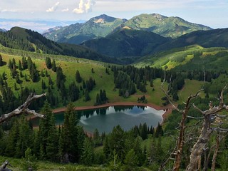
The photo of Lake Desolation was taken from the ridge about a quarter mile northwest of the summit. It is a rough ridgeline to follow but the view of the lake is very nice. We followed the ridge until we were just above the Crest Trail and took it back to the junction before heading home, that's the notch in the elevation profile below.
Photos
GPS Tracks: kml gpx
Google Maps: Terrain

Saturday, July 26, 2014
Clayton Peak & Preston Peak


Photos on Facebook
We started off the hike with a restroom stop at the Silver Lake trailhead parking lot and then drove over to the Brighton parking lot where we got some guy to take a body recovery photo. We followed the left side of the main base ski area, ignoring the signs for the popular Lake Mary Trail where you can hike if you like a bumper-to-bumper affair with zillions of sweaty zombies trying to escape the heat of the valley. No place for seasoned and snobby hikers like us.
We got off the trail a bit after we went by the bottom of the Pine Martin lift, we should have found a road/trail that went more northeast, instead (my bad) we followed the road that took us way too far north. I talked Jen and Tina into bushwhacking up the hill and meet the trail on the ridge. It worked out though I got a ton of burrs on my socks and Tina whined about biting flies a lot. There was a lot of brush/undergrowth and a few steep spots but it was a reasonable recovery. Once we made it to corner of the Silver Spur ski run, we were back on track. There wasn't as much trail on the Elk Park ski run section as I expected, just a slog up the ski run with a few recent ATV tracks to knock down the tall wild grasses. Once the ski run turned into a cat track it was easier going.
We turned the corner onto the Western Trail which was a gravel road used by trucks I'm sure. The top of the Great Western lift was quiet and I had to prevent Tina from trying to turn on the lift. Past the lift the trail was a steep single track that wound up the rock until we made the summit ridge. Turning back towards the summit of Clayton Peak, the trail soon became a fun boulder scramble, nothing too scary. We ate some lunch, fed a chipmunk and took some photos.
There was a steep, switchback trail down the SSW ridge of Clayton Peak until we regained the service road. There wasn't much breeze and the flies were swarming along the road so we hurried on our way. We passed by the top of the Snake Creek Express lift and continued on to Preston Peak, the trail quickly because a single track with little obvious use. We picked our way through the brush and trees trying to get to the summit. The summit of Preston Peak was a major let down except for a very nice looking, metal plaque on the side of a boulder. There was no clearing, no view and red ants were swarming. Tina tried running away but I made her stop for a photo with the plaque.
We found a faint trail that roughly continued along the ridge until we came to a very steep stop we eased down to regain the ridge service road. We stopped for Tina to clean out her shoes at the top of the Crest Express and took more photos. We followed a service road down until it crossed a real trail and turned towards the Dog Lake area. THe trail eventually dropped us onto the Lake Mary Trail and the swarms of wussy hikers got in our way. After knocking a few people down we made our way down to the Brighton parking lot. Is anyone reading this any more?
GPS Tracks: kml Live Google Maps: Terrain (TOPO) View

Sunday, June 22, 2014
Slate Canyon
 Slate Canyon Trail
 Luna and I hiked up Slate Canyon today, at the pass between Slate and Slide canyons, we followed a trail east for about another half mile. It connects to the Provo Peak Trailhead but we didn't quite make it to the top of the ridge before turning back. I will probably hike the rest of it from the other side and hike the ridge up to the top of Horse Mountain.
Round trip was about 9 miles.
GPS Tracks: kml gpx Google Maps: Terrain

Thursday, March 24, 2011
The Moonshine Snowshoeing Club 3-24-2011 Outing


Tuesday, March 22, 2011
The Moonshine Snowshoeing Club 3-22-2011 Outing


Sunday, March 20, 2011
Snowshoeing with Luna


Sunday, March 6, 2011
Cross County Skiing the Alpine Loop at Night

Jack made me cross country ski last night, it was ok but I have more fun snowshoeing, I think sticking to the road is a bit monotonous and I'm really not that steady on my classic XC skis, especially in the dark. I didn't go al the way to the top of the Alpine Loop (yellow part), I turned around when my feet started hurting.
The profile is a bit crazy, it sure doesn't feel like such a gradual, consistant incline. It feels more like flat with a few steeper sections.
GPS Tracks: kml gpx
Google Maps: Terrain

Sunday, February 20, 2011
Squaw Peak Overlook

I wanted to snowshoe up at Aspen Grove today but when I was turned back when Provo Canyon was closed for avalanche control, I drove up to the gate on the Squaw Peak Road. I snowshoed up the ridge above the gun club shooting range and followed the cleared areas that were made for wildlife over the summer. I eventually made it back on the road and crossed over to the west side and followed the last ridge up to the Squaw Peak Overlook. There was plenty of snow with drifts of up to 4 feet above the surrounding snow. I was wearing a shell since snow was falling the whole way with light to moderate wind. I followed the west ridge down until I got back on the road and took it down the rest of the way. In all it was about 5 miles round trip in about 3 hours.
Tuesday, January 25, 2011
 Jack, Charlie, Luna, White Paw and I made a run up Lame Horse Point at night. It was a brutal climb in the powder where the switchbacks show in the track on the last section up the ridge. This is the furthest up the ridge we have ever made it at night. We came down the ridge to the point and enjoyed the view. There wasn't much moon but we could see the snow cats grooming the slopes at Sundance. We continued down the north ridge until it became too steep and then cut back into the trees on the north facing side of Lame Horse Point.
Saturday, March 27, 2010
Delano Peak

We snowshoed in from the trailhead to the Yurt (4.5 miles) the first day; the weather was warm and sunny but the snow conditions were very poor for shoeing; soft and wet snow the whole way. We followed a trail well worn by snowmobiles. Even in a thin workout shirt, I was hot all the way to the Yurt. Jack started out skiing up with skins but switched to snowshoes due to boot problems.
Snorkeling Elk Yurt is the Marriot of winter camping. A large dome skylight enabled the sun to warm the Yurt to 72 degrees when we arrived. The Yurt has a good sized wood stove which we fired up to dry some wet clothing. Jack and I both got our skis out to take a spin a while after arriving at the Yurt. I was tired but needed practice for the trip down the next day. In the evening we cooked on the provided propane stove and had a quiet evening.
After turning in early, Jack and I took turns stoking the stove every couple of hours. The Yurt stayed fairly warm as long as the fire was going. I went outside at one point for a 'natural break' and the stars were amazing. In the morning we made hot drinks to have with breakfast and prepared for our summit attempt. The weather report had predicted strong winds in Beaver, UT so we were worried that the summit might be crazy.
It was fairly cold but sunny when we started out for the 1.7 mile climb to the summit the second day, the snow was very firm, great for snowshoeing. We were able to go up steep slopes with no worries about grip. The sun was out most of the way up, as we got about a half-mile from the summit the wind picked up quickly. About 300 yards we dropped our snowshoes to cross the tundra ridge blown clear of snow by 50+ MPH winds. At the 12,174 ft summit of Delano Peak there was hard snow and the wind was slightly less fierce. We only spent about 6 min at the peak taking a few photos and some video. Luna was franticly trying to find some shelter from the wind. We headed down quickly fighting the wind and blowing snow. We strapped our snowshoes back on and high tailed it to the shelter of the ridge. The transition to and from gale force wind to the pleasant weather behind the ridge was sudden and amazing, light night and day. On the way down, we glissaded a few sections to the delight of Luna who loved running down the steep slopes.
Unlike the day before, the snow was hard and crusty between the Yurt and the trailhead. It was very difficult skiing down with a heavy backpack on the snowmobile tracked trail.
Trailhead to Yurt: 4.75 miles 1700 vert ft - 2:45 up )snowshoes), 1:40 down (skis)
Yurt to Delano Summit: 1.7 miles 1800 vert feet – 1:45 up, 42 min down
Note: Jack could have skied down in under an hour if I hadn't been slowing him down.
Photos: FB
GPS Tracks: kml gpx
Google Maps: Terrain

Sunday, January 31, 2010
Big Baldy - Winter/Snowshoe Trip

Jack and I planed a trip up Big Baldy and undertook the trip just an hour and a half later. We left the vehicle a little after noon and headed up the road to the trailhead. The Dry Canyon trailhead is closed in winter so we departed from the gate in Lindon and headed up the road which was snow packed in hiking boots. We greeted several groups coming down the road.
As we started up the hiking trail (049) in Dry Canyon the surface continued to be snow packed with a few bare spots and a little bit of mud. The air temperature was fairly warm, I was hiking in only a long sleeve exercise shirt. We continued in hiking boots up past the Curley Springs Trail (051) junction.
We put our snowshoes on at the turn off of 049 onto the Big Blady south ridge trail. At the turn the trail had was untracked snow. Near the bottom there were a few rocky spots in sunny exposures where the snow had melted through but was mostly snow covered. As we climbed the snow became deeper, we picked up several tracks on the way, a few boots and a few snowshoes. At times the snow was heavy and wet and a short distance away, around to the east was light and powdery. This is a very steep trail, Jack and I took turns breaking the trail keeping up a good pace. Existing snowshoe tracks were often but not always the best line up the ridge. The sun was making the exposed areas of snow wet and soft, Jack had problems with snow sticking to bottom of his snowshoes.
We reached the flag pole at front peak in about two and a half hours. We took a few photos and decided to continue on to the snowy summit. We shoed along the snowy ridge and made it to the summit in another 15 minutes.
We spent about 25 minutes at the summit before heading down. The steep parts of the decent we quite unpleasant. The footing was unpredictable between sliding and stopping on buried rocks or brush. The less step sections were quite a bit easier but the existing packed trail we came up was usually not the best footing. One of Jack's snowshoes had an equipment malfunction near the bottom of the south ridge and he was forced to hike the rest of the way in his boots. When the trail turned to as much rock as snow I took my snowshoes off and wished I had my Yak Tracks. The footing in boots was very poor.
The mile on 049 was very muddy, a noticeable amount of the trail had melted since our way up and we kept out of the mud as much as possible walking on the side of the trail in grass or snow. The trip down took us about an hour and 45 minutes.
To front peak (flag pole): 2:30 hrs:min
Front peak to summit: 15 min
Vertical: 3500ft
GPS Tracks: kml gpx
Google Maps: Terrain

Friday, November 27, 2009
Mahogany Mountain from Grove Creek

Jeffry and I decided to work off some of the Thanksgiving food with a fast hike up to the summit of Mahogany Mountain from Grove Creek Trailhead via the southwest ridge. We had done this hike before one day when we couldn't find the trail we had planned and it turned out to be the hottest day of the summer. In the contest of men vs. mountain I would say that hike was a draw. Today however the the men won. We hiked the 7.1 miles in a hair under 5 hours and left the mountain whimpering. Bushwhacking up the southwest ridge made for a steep climb but the hike along the rideg from the south point is mellow and we cruised to the summit without stopping on this section. This was a very nice hike.
GPS Tracks: kml gpx
Google Maps: Terrain

Sunday, November 22, 2009
Big and Little Baldy Loop

The forecast was for rain but blue skies in the morning made me think Big Baldy would be a good hike for today. I've wanted to hit both Big and Little Baldy in one hike so I decided if I wasn't too tired on the way down I would loop around on the Great Western Trail and hit Little Baldy on the way back.
Nutmeg and I started form the Dray Canyon Trailhead at about 9:00am. The air temp was quite cool in the canyon so we moved briskly and went up the south ridge of Big Baldy which is a well established trail but not an official Forest Service numbered trail once you turn off of 049 about a mile up from the trailhead. The south ridge is brutally steep (see the profile below) so if you want a more mellow hike stay on trail 049.
We got to the front peak, the one with the flag pole, in about an hour and 45 minutes and got to the true summit in another 15 minutes. I took a phone call just as I reached the peak and after five minutes started to get cold so we headed down to the saddle at a brisk pace to warm up. There was a bit of snow on the more north facing side but nothing more than about 4 or 5 inches. There were tracks from a hiker or two that looked only a few days old.
From the saddle behind Big Baldy we followed the Great Western Trail down trail 049 to the trail 033 junction and then to the saddle behind Little Baldy. There is a very faint trail from this saddle up the back of Little Baldy. I did notice some orange trail markers but with snow on the ground it was a bit of work to follow the trail. Peak to peak was about two miles and took us about 55 min.
At the trail 033/trail 051 junction we had a bit to eat and drink. We tried to follow trail 051 back to Dry Canyon but somewhere along the way I lost trail 051 and ended up coming down too far south. I knew where we were when I came to Sushi Hill and just followed the trail down to the Bonneville Shoreline Trail and then headed north back to the truck.
Distance: 10.4 miles
Time: about 5.5 hours
Avg Speed: 2 mph.
GPS Tracks: kml gpx
Google Maps: Terrain

Sunday, November 15, 2009
Friday, October 16, 2009
Buffalo Peak from Indian Road Trailhead

A training hike for our trip to Ecuador, we started at Indian Road Trailhead near the mouth of Provo Canyon and hiked up hill for 5 miles all the way to Buffalo Peak and then back down again with a few alternate trail sections.
Distance: 10.1 mi
Min Alt: 4910 ft
Max Alt: 8015 ft
Vert Feet: 3105 ft
Avg Speed: 2.0 mph
Start Time: 7:45
End Time: 12:42
GPS Tracks: kml gpx
Google Maps: Terrain

Sunday, October 4, 2009
Battle Creek to Grove Creek

Between Provo Canyon and American Fork Canyon the two nicest hikes are Grove Creek and Battle Creek and this hike hits them both. I was invited to join two experienced international trekkers who are training for a trip to Ecuador later this year. For info about their organization see Trekking For Kids. It was nice to leave the planning and arranging to others and just 'be along for the ride'. We left a vehicle at the Grove Creek Trailhead and drove to the trailhead for Battle Creek Canyon at Pleasant Grove's Kiwanis Park. I've hiked this combination of canyons as a loop by returning to the original trailhead on a fairly uninteresting section of the Bonneville Shoreline Trail that runs between the two trailheads but it does extend the hike to over 8 miles and can seem a lot longer especially on hot days.
There were quite a few hikers rallying at Kiwanis Park as we arrived. We quickly donned our gear and headed up the canyon. Mel and Trisha each brought their dog along on the hike and both proved to be excellent hikers and kept to the business at hand. It was cool but not as cold we expected, our worries were being too hot and that we were carrying too much warm clothing.
We started out at 7:40am passing other groups once in a while as we did throughout the entire hike. The trail surface was dry and though I had feared walking through wet grass in the sections where it overhangs the trail the foliage was also dry. The air temperature was cool, perfect for a brisk pace up the fairly steep climb of Battle Creek Canyon.
We reached the junction with trail #049 and The Great Western Trail in about an hour and 20 minutes having covered 2.3 miles. The next 1.6 miles section follows along 'Timpanogos Perimeter' section of The Great Western Trail which crosses the Timpooneke Road which is vehicle accessible in the summer from the Timpooneke Campground/Trailhead in American Fork Canyon. The section is generally flat with a few hill, we were able to keep a 3 mph pace and cover the distance in about 35 minutes. After a short downhill section there is one short section that follows an old CCC (Civil Conservation Core) erosion terrace that has only a faint trail. In places there was grass obscuring any definite trail. Follow the level terrace and the obvious trail will reappear shortly before the junction.
The section ends in 'Sagebrush Flat' where trail #049 makes a four-way intersection with #048 which is the Grove Creek Canyon Trail. Turning west we began the longest section of the hike, the 3.3 mile descent down Grove Creek Canyon.
Not too far from the intersection is a sign along #048 marking 'Grove Spring' and 'Indian Campground'. The spring is interesting because in a relatively flat spot the water seems to bubble straight up from the ground and flow away. The dogs enjoyed a drink from the cool, clean water. After crossing over the edge of Sagebrush Flat and a few small streams the trail switchbacks down the south side of the canyon and crosses over Grove Creek proper at a cute little bridge. On the north side of the canyon, the trail becomes much more rocky and there are some ledges and eroded sections require careful footwork. The downhill slope is fairly gentle and consistent, a much easier descent than either Battle Creek Canyon or Dry Canyon to the south. The very end of the hike after the long switchback does get a little bit steeper but it is quite short. We covered the 3.3 miles in an hour and 25 minutes, about 2 mph. It was a very pleasant hike, Mel, Trisha, Luna and Xander were great hiking companions. We all were comfortable with the pace of the group.
Links:
- "Battle and Grove Creek Trails", Salt Lake Tribune, June 2007
- Grove Creek to Battle Creek Loop, Mike's Walk Talk, October 2008
GPS Tracks: kml gpx
Google Maps: Terrain

Thursday, September 24, 2009
Mount Nebo & North Peak

In my mind, Mount Nebo was a monster. Several people I have talked to told me it was a hellish hike that they never wanted to do again. Since the "Nebo Group" is the last section of the Wasatch Eleveners book I had never really read the section, just skimed it a few times.
I studied the section the night before the big hike and after some initial confusion was please to see that the summit of Mount Nebo is the northern peak and only requires a 10 mile roundtrip hike. The confusion stemmed from the fact that there is a separate mountain called North Peak that is just north of Mount Nebo's north peak and is also an official Wasatch Elevener and is accessed from the same trail.
Once the confusion lifted I planned the hike to cross North Peak (11,155 ft) and then climb Mount Nebo's north peak (11,928 ft) and finally return while bypassing North Peak.
Kirk and I started hiking at about 7:10 from the trailhead after about and hour and a half drive from Orem. There were several groups of hunters along the lower parts of the trail and we heard distant gunshots, I believe it was muzzle loader season and even though it was a Wednesday there a lot hunters around. We crossed a dry Gibson Creek after two miles in about 45 minutes. The trail became significantly steeper after this point. At 2.5 miles from the trailhead we left the main Mount Nebo trail in order to climb to the summit of North Peak. There was a faint, spotty and sometimes multiple trails running up the north ridge of North Peak. A cold wind was blowing over the ridge from the east side so we stayed on the west side of the ridge when possible. There was a trail that contoured around to the west about 100 ft of altitude below the summit, we followed this trail mostly to stay out of the cold wind. When I noticed that we were past due west of the peak we turned up hill and bushwhacked the final 200 ft to reach the summit of North Peak. We took a couple of photos and quickly headed out to continue on to the primary goal of the hike.
There was no trail down to Wolf Pass where we would rejoin the Mount Nebo trail but there were many human footprints headed in the same direction. There would a few slides of scree which we had fun loping down. Wolf Pass is at the 3.5 mile point on the trail which we reached 2 hours into the hike.
It took us another hour and a half to travel the last mile to the summit of Mount Nebo. The trail was very steep and hard to follow in places when it either became faint or broke into several branches some of which ended abruptly. There were a few cairns some of which we missed and didn't see until the return trip. There was a small but sturdy metal mailbox at the summit containing a log book for hikers to write a message and/or sign. On the summit we had a bite to eat, took photos, signed the log book and did a little foot maintenance.
We took our time on the hike down stopping to enjoy the views and take some photos. The return hike ended up taking about 3 hours and 10 minutes. I would rate this hike much easer than Mount Timpanogos, in fact I would rate this hike as easy or easier than most of the other Wasatch Eleveners. Only Monte Cristo/Superior and Red Baldy come to mind as less of a challenge. The worst part of this hike is how much wasted ascending there is, the profile graphic below shows how many humps are crossed in both directions. The best part of this hike is getting bragging rights for climbing the highest peak in the Wasatch.
GPS Tracks: kml gpx
Google Maps: Terrain

Saturday, September 19, 2009
Dromedary Peak

GPS Tracks: kml gpx
Google Maps: Terrain
Mel Hall and I set out to tackle this peak on a remarkably pleasant September morning. We left the Mill B South trailhead in Little Cottonwood Canyon just after 7:00am to head up the Broads Fork Canyon. We made great time through the pretty, wooded, two mile section of maintained trail up to the beaver pond getting there in an hour and a half. The next one mile section of the trail is unmaintained and has lots of obstacles climbing the drainage above the beaver pond to the rock pile in about an hour. The next section is an open talus slope on the east side of the bowl ringed by Broads Fork Twin Peaks, Sunrise/O'Sullivan and Dromedary Peak. We made the saddle on the north ridge of Dromedary in about an hour and a half covering just six tenth's of a mile. The final two tenth's of a mile scramble to the peak took another hour negotiating many tricky rock climbing sections I would rate as class 4. Apparently there is an easier route to the top if you traverse around to the east ridge at some point after the saddle but I didn't learn about that until after the hike.
The descent was long and slow taking four and a half hours to retrace just 4.2 miles with the peak scramble retreat taking and hour and 20 minutes to get back to the saddle.
The trail profile graphic below correctly sums up the hike as: steep, steeper and steepest. About 4900 vertical feet over 4.2 miles, 8.4 miles round trip.

Subscribe to:
Posts (Atom)
