The trailhead for this hike is the large Brighton Ski Resort parking lot, there's no fighting for a space like Mill B South. You can park on the southeast side near the main lodge, the northwest side where the hike begins or anywhere in between depending on whether you want to cross the parking lot at the beginning or end of the hike. I like to park in the middle and look down from the summit of Mount Millicent and see my vehicle, it gives one a sense of accomplishment. There are not usually any restrooms available at the ski resort in the summer, you have to visit the "Nordic Center" along the loop about a 1/4 mile before the Brighton parking lot.
The hike starts at the base of the Milly Express ski lift at the northwest side of the parking lot. Right next to the lift begins the service road that winds back and forth climbing all the way up to the top of the ski lift. The road passes by the Twin Lakes Reservoir dam where you can stop for a photo or just enjoy the view. You can also choose to hike up the ski slope which varies from steep and grassy to smooth bedrock. The ski slope is more direct but much steeper. Save your legs for the next part if you are in doubt, there's no easy way up the boulders.
At the top of the lift begins the boulder scramble. The boulders vary from car sized to bread boxes. There's no trail, just head uphill and avoid where the pile of boulders is too steep. I like to put away the trekking pole and wear leather gloves for this part. The easiest path is near the crest of the ridge but some of the best views are on either side. There are several false peaks, the total vertical is about 600ft but feels like a lot more than six stories. There are several avalanche control devices on the sides of Mount Millicent. They look like giant faucets but appear to be nematic with hoses running all the way up the ridge from a shack. When you reach the summit be sure to take time to enjoy the view on all the sides especially on a clear day. It took me about 2 hours to reach the summit form the parking lot, I stopped to take photos and catch my breath many times.
The next part of the hike is descending down the back of Mount Millicent just enough to get up the ridge to Mount Wolverine. There are a few places you need to zig-zag around trees and boulders but try to head southwest and avoid descending to far by staying close to the southwest ridge. The terrain will turn from boulders to a grassy soil with occasional rocks as it bottoms out and you start heading up Mount Wolverine. There are some good views on the ridge towards Twin Lakes Reservoir but you can make your way up the steep meadow wherever it looks easiest. As you approach the top there is a fairly obvious trail that will lead you to the rocky top of Mount Wolverine. Though the Millicent side of Wolverine is not terribly impressive, when you look down to the southwest you will see much of the Alta ski resort. The southwest side of Wolverine is a very steep slope. On a clear day you can look out the mouth of Big Cottonwood Canyon and see the Bingham Copper Mine (Kennecott) across the Salt Lake valley. Many of the famous peaks of the area are visible including American Fork Twin Peaks, Lone Peak, Mount Baldy and the red peaks Superior, Dromedary, Sunrise, etc.
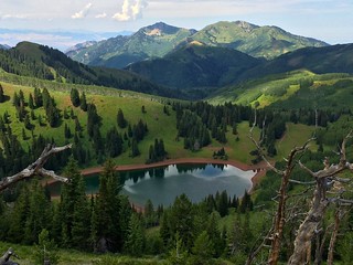
Thankfully the hike over to Mount Tuscarora is much less work. There is an obvious trail that leads the way. There are several hills of rock along the way. Don't miss the summit, there are some spectacular views of the Lake Mary, Lake Martha and Lake Catherine from Tuscarora and some impressive cliffs under the summit on the northeast face. The highest mound of boulders is not super obvious so be careful not to walk past it.
The next section of the trail is the most difficult and may make some nervous. The trail winds down steep rocky and sandy terrain among some older conifers. Take you time and make sure your footing is secure, a tracking pole may help to feel a bit more secure. The trail flattens out a bit as you approach the trail junction at Catherine Pass. To get back to the trailhead head down to the northeast towards Lake Catherine. You may not have seen any other hikers up to this point but there has always been people at the pass every time I visit there. The trail back down to Brighton will become increasingly crowded. There are usually many people at Lake Mary, sometimes it is hard to even get a photo without a bunch of other hikers getting in the way, especially in the afternoon. There are a few optional side hikes on the way down, you can take a right at the first fork to visit Lake Catherine up close and a trail that goes the long way around the lake. You will visit Lake Martha and Lake Mary on your way. A ways after Lake Mary there is a side trail up a short way to Dog Lake if you want to maximize your experiences. The trail eventually leads down to where you cross under the Crest Express ski lift and down the Majestic ski slope.
As I hiked it, the total distance was just under 6 miles. With the up and down of the peaks the total accent is about 2200 vertical feet with Mount Wolverine topping out at 10,764ft according to the USGS. Mount Millicent is listed as 10,400ft and Mount Tuscarora 10,617ft.
GPS Tracks: kml gpxGoogle Maps: Terrain