
Wednesday, July 30, 2008

Tuesday, July 29, 2008


Sunday, July 27, 2008


Saturday, July 26, 2008
Mahogany Mountain Peak from Grove Creek

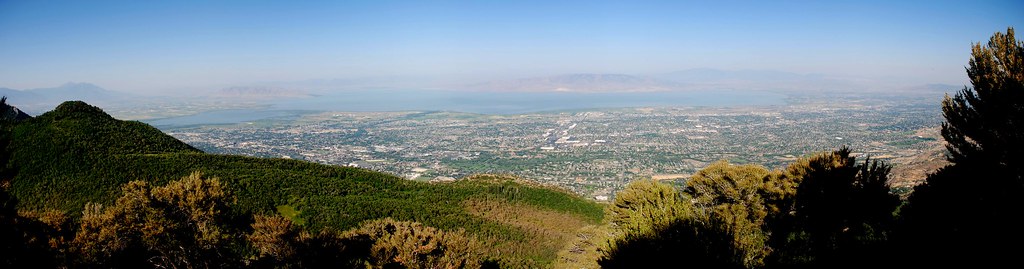
As promised, this hike did indeed turn out to be the most challenging outing in the short history of the Intuit Utah Hiking Club. Jeffry, Dave and I departed the parking lot at about 7:05am. Besides stopping to locate a couple of geocaches, we made excellent time for the first three miles. The trail up Grove Creek is very nice. There is a little steep hill at the beginning but then it quickly mellows out into a really enjoyable walk. There is nice waterfall and some gorgeous mountain views. I would recommend anyone who likes walking should give it a try. You can go up however far you like and make the walk any length you want.
Unfortunately the well traveled path did not match the trail on the topo maps which threw us off track a bit. As Jeffry and I planned how best to get back on track Dave decided he was going to head back to the trailhead. Dave had planned on going two or three miles up so the trail adjustment came at just the right time.
Jeffry and I decided to bushwhack over to where the trail was marked on the map and continue on. As it turned out, there was no obvious trail that we could find but we used some info from other hiker’s reports on the internet to make a direct assault on the Mahogany Mountain ridge. We continued bushwhacking now going up the side of the ridge where the track enters the shadow in the map above.
Though the terrain was steep we soon scaled the ridge and stopped for pictures from the end where it overlooked Grove Creek. We could now see the peak to the north and began the final climb. Though there was no real trail, the hiking was fairly easy along the ridge. There were a few bands of trees we had to pass through but other than that the hiking was straight path to the peak. The temperature had risen to 100 degrees and the sun was straight up. I made the peak just around noon with Jeffry about ten minutes ahead. We drank, ate, took photos and enjoyed the view from the peak for about 15 minutes before heading down. We were able to see the fire by Bridal Veil Falls from the Peak but noticed from the trail head that it had kicked up considerably during a decent.
From the peak, Jeffry spotted what he thought was a fairly reasonable way down the front of the mountain straight to Cedar Hills. Since the trail we had planned for both up and down hadn’t been obvious I agreed to go for the direct approach. At lease I was sure our cell phones would work on the front of the mountain so it would be better that getting stuck in the back. I made sure Jeffry knew I was going to blame him for any problems we would encounter.
The going was much tougher than we had expected but at least it was all down hill. We both had some blister issues and I stopped and put on some fresh socks at one point. I tried to get some directions from Dave over the phone by having him look up our position on Google Earth but in the end Jeffry was able to make a path to the bottom. My biggest fear was getting to a dead end (like cliffs) and having to climb back up to get around an obstruction. Thankfully we avoided that situation, well, mostly.
We called in a ride from Jim Ferry and he was nice enough to give us transportation to the trailhead from where we made it to the Cedar Hills streets. It was a very hot day for such a long hike and most of it was on the sun baked hillsides. Our bushwhacking did save us a mile over the planned trail but probably not any time.
GPS Tracks: kml gpx
Planned Trail: kml gpx
IUHC Photos on Flickr: Mahogany Mountain Peak Other Hikes


Thursday, July 24, 2008

Wednesday, July 23, 2008


Tuesday, July 22, 2008

Sunday, July 20, 2008
Pioneer Peak
 |  |
This is a very nice hike that doesn't get a lot of traffic. I parked at the the spot that the jeep trail leads off from UT 220. The jeep trail is passable by any 4x4 for at least a mile, the next section is passable by a real jeep and an ATV could make it all the way to the saddle that overlooks Brighton. The trail is often quite steep and has switch backs to climb up to the ridge. From the saddle that overlooks Brighton there is about a quarter mile of single track trail that traverses the ridge up to the peak. It is sketchy in a few spots and but there really is trail that goes al the way to the peak.
A very nice view from the summit, Sunset Peak to the southwest, Millicent, Tuscarora and Wolverine to the northwest and Clayton Peak to the northeast. You can see the top of the tram at Snowbird in the distance as well as...
<To be continued...>
GPS Tracks: kml gpx

Pioneer Peak from UT 220 (Midway Side)
| |
This is a very nice hike that doesn't get a lot of traffic. I parked at the the spot that the jeep trail leads off from UT 220. The jeep trail is passable by any 4x4 for at least a mile, the next section is passable by a real jeep and an ATV could make it all the way to the saddle that overlooks Brighton. The trail is often quite steep and has switch backs to climb up to the ridge. From the saddle that overlooks Brighton there is about a quarter mile of single track trail that traverses the ridge up to the peak. It is sketchy in a few spots and but there really is trail that goes al the way to the peak.
A very nice view from the summit, Sunset Peak to the southwest, Millicent, Tuscarora and Wolverine to the northwest and Clayton Peak to the northeast. You can see the top of the tram at Snowbird in the distance as well as...
GPS Tracks: kml gpx


Saturday, July 19, 2008
Buffalo Peak


We left the parking lot at 7:05am with eighteen fresh legs. The trail immediately set the tone with steep climbs and ify footing. As if to intentionally prove me a liar when I claimed this trail would be "less challenging", it tested the mettle of all eighteen legs. The eight shortest handled the trail without even a whimper. The group, Mel, Kristine, Allen (Kristine's husband), Mark U, Mike, Chewy and Kona made steady progress despite the trail's non-less challenging nature.
Eventually the trail claimed its first victim when Kristine begged us to leave her behind to be eaten by the mountain lions. She said she should at least make the pride stronger, Eskimo-style. Though I took a solemn pledge to never leave a man behind, women occupy a tricky gray area. We sprinkled her with seasoning and garnished with a sprig of parsley and then kept going.
There was discussion about which peak in front of us was our goal just as we rounded the hill guarding the north side of the very top of Canyon Creek canyon [Little Rock Canyon as the locals refer to it]. From a height over 100 feet higher than Squaw Peak, the summit of Buffalo Peak stared down upon us. When we got to the large fire ring at the very back of the canyon we could hear the sounds of vehicle traffic on the Squaw Peak Rd where it neared the trail. We continued on walking in the shadow of Cascade Mountain until we broke into the sun about 8:30am.
We made the peak at about 8:50am and enjoyed the somewhat hazy view. Granola Bars were eaten, pictures were taken, stories were told and dogs were watered. After about 15 min we headed back down the trail.
Mel left the group to head back in time to host a breakfast for friends while Mark and I played with a reluctant snake. We encountered a lot of wildlife including this lizard and this fuzzy caterpillar. As the saying goes, haste make waste. Mel took a wrong turn and ended up rejoining the group from behind and arrived back at the trail head with the rest of us at about 10:20am
GPS Tracks: kml gpx


Sunday, July 13, 2008
Provo Peak


Though the track shows 3 miles, my real distance was about 4.5. I did a bunch of back tracking that I took out of the track. First of all, I had a hard time finding the walking trail turn off from the ATV trail. After finding it on the way down, I'm not sure I would ever have found it without a track on my GPS. There was a cairn but I had seen it and thought it was a marker for a camp site or something else private.
The first part of the trail is an ATV trail that ends up following one of the CCC terraces. The ATV trail ends abruptly. As you can see from the track, the path up I took included an out of the way loop which was somewhere between bushwhacking and following game trails. As it ends up I covered this section three to five times from backtracking various sections. First I went back down to see if I had missed the trail at the end of the ATV trail. After searching some more, I decided I couldn't find anything better so went all the way up to another terrace about 0.2 miles up steep mountain side with sometimes thick aspen. I walked along that terrace to the left which was a wrong turn. I let Nutmeg off the leash and she got herself stuck in a ravine. I couldn't find anyway down since the ravine was lined on the near side with incredibly thick aspen. I headed back down to the ATV trail to see if I could get to the ravine there. Nutmeg found a way up and I headed back up that section again realizing I need to go the other way on the terrace.
We stopped at a spot of snow where Nutmeg got her fill. When we finally made it to the correct ridge we picked up signs of other hikers and headed up to the Peak. The trail was very steep and rough. I could see boot tracks that looked fresh. Eventually I spotted two hikers ahead in white shorts. They were on a steeper section above and were separated by a fairly big distance. The lower hiker kept looking back at me seemingly bothered that I was catching up.
Nutmeg an I took our time and stopped for a snack and water a few times. Subconsciously I wanted to hurry and catch up but Nutmeg was showing signs of being uncomfortable from the heat I hoped. I made sure she got plenty of water and rested often. This was the highest I had ever taken her so I didn't want to push too much.
There were several false peaks as I had been warned. I lost sight of the hikers above after they went over the first one. After I had made it to one of them I found a 16-20 year old male laying on the grass above a rock outcropping. He said he didn't think he was going to make it because he had spent the last two weeks at sea level. I told him it was only 0.22 miles to the peak and he started moving again following me up. He mentioned that the other hiker was his father. We got up another 0.08 of a mile when his father came down from the peak. I lingered as he conversed with his father for short time and then started following him down. I was amazed that he abandoned the climb just over a tenth of a mile from the top.
Nutmeg and I made it to the top eventually. We hung out up there, had a snack and took some photos including a few panorama sets. We started down and I noted a large snow bank we could reach from one of the false peaks. We stopped there and Nutmeg chowwed down on the snow. You can see the short spur on the track about a quarter of the way down (from the right). I got out a drink mix packet and made a snow cone in my canteen. I ate it as we headed down.
Eventually we came across a couple come up the trail. They had a well behaved dog that Nutmeg greeted nicely. I gave them the measurement to the top and we chatted for a while. I mentioned the snow and snow cone (they could see the red color on my lips). I gave them a drink mix packet. They had come up the same way as me, it probably looks like a well worn trail now! They didn't ask the father and son either. Eventually we both moved on in our opposite directions.
I took a few spills on the way down. The rocks and gravel were very unpredictable, some times firm and sometimes gave way with little resistance. I really scared myself once when I fell forward but my knee went into a 'soft' pile of gravel and it stopped me and really didn't hurt. I did get a few bruises on one tumble. Some sections were worse than others with soft or hard dirt, loose or stable rocks and crumbly ledges.
I was able to follow the 'correct' trail all the way down. When I saw the missed turn I wasn't at all surprised at all. The walking trail up was totally invisible from the level ATV trail. I took a few minutes and made a large arrow with rocks on the trail near the cairn I (and the couple) had ignored. I still doubt I would have turned there but I may have returned to that spot when the I reached the end of the ATV trail. It really needs and official looking sign but I don't think that it's really even an official trail. All photos on the blog dated 7-13-08 are on the hike.
GPS Tracks: kml gpx

--- Snowcones at 10559ft

Nutmeg also loves to eat the snow (natural flavor) and on a hot day I
put a little under my hat.


Subscribe to:
Posts (Atom)
